Final Google Earth Files
I have taken all of the final GPS data Shane provided from the boat and from the car trips on Madeira and to Marrakech and converted it to the following Google Earth files:
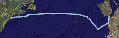
 The entire trip, boat and car excursions all together in one file:
GPS_Boat+Car.kmz (125kB)
This file contains boat and wind vectors in addition to the GPS Lat & Long information.

The road trip on the island of Madeira:
GPS_Car_Madeira.kmz (34kB)
 The car trips to and from Marrakech:
GPS_Car_To_Marrakech.kmz (18kB)
GPS_Car_From_Marrakech.kmz (16kB)
Just the at sea portion:
GPS_Boat.kmz (56kB)
This file contains boat and wind vectors in addition to the GPS Lat & Long information.
 All of these Google Earth files have folders like you see here. The one shown is for the entire trip kml file. If you check the boxes off and on for each sub folder this will allow you to selectively show or hide that portion of the trip.
Craig
 The entire trip, boat and car excursions all together in one file:
GPS_Boat+Car.kmz (125kB)
This file contains boat and wind vectors in addition to the GPS Lat & Long information.

The road trip on the island of Madeira:
GPS_Car_Madeira.kmz (34kB)
 The car trips to and from Marrakech:
GPS_Car_To_Marrakech.kmz (18kB)
GPS_Car_From_Marrakech.kmz (16kB)
Just the at sea portion:GPS_Boat.kmz (56kB)
This file contains boat and wind vectors in addition to the GPS Lat & Long information.
 All of these Google Earth files have folders like you see here. The one shown is for the entire trip kml file. If you check the boxes off and on for each sub folder this will allow you to selectively show or hide that portion of the trip.
Craig
posted by Botanika at 12/12/2006 12:07:00 AM
![]()

1 Comments:
Thanks Craig for putting together such a wonderful way of viewing our voyage. Also, congratulations on the new addition to your family!
Post a Comment
<< Home